Enjoy complimentary customisation on priority with our Enterprise License!
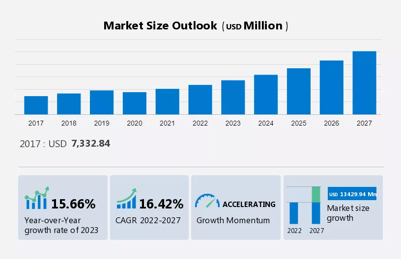
The GIS market is forecast to increase by USD 13.43 Billion at a CAGR of 16.42% between 2022 and 2027. The Geographic Information System Market sees notable growth with increased applications in disaster management, utilizing Spatial Data Analysis. This technology aids forest fire, flood, and climate change management, crucial for government and natural resource sectors.
For example, in forest fire management, 3D GIS assists in fire risk assessment and post-fire monitoring. Another significant trend is the demand for technology miniaturization, expanding Geospatial Technology and Remote Sensing capabilities. Miniaturized sensors enable enhanced data collection for disaster response and environmental monitoring. This trend drives growth in Geographic Information Science, indicating a promising Growth Rate for the market.
To learn more about this report, Download Report Sample
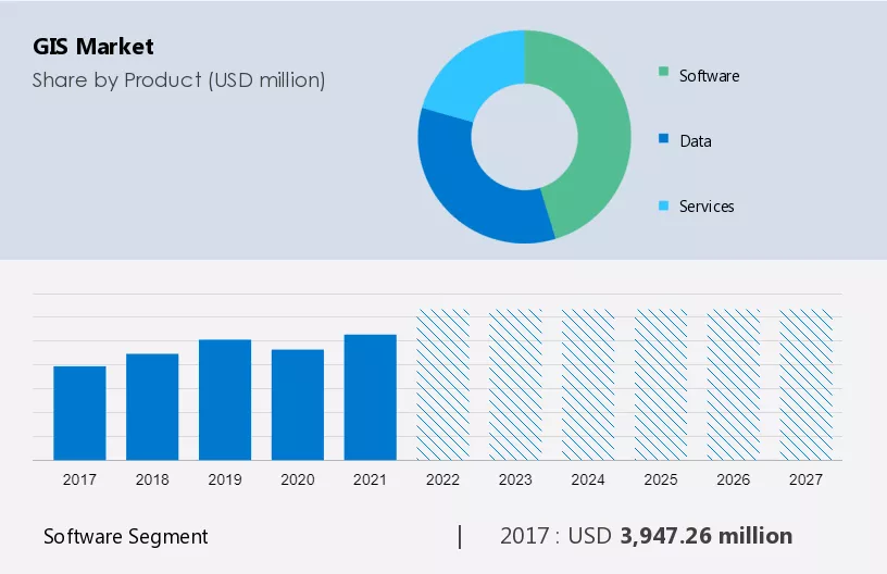
The market share growth by the software segment will be significant during the forecast period, as indicated by market forecasting. The software segment, comprising software for desktops, mobile devices, cloud solutions, and servers, is poised for market growth and trends. The software available in the global market is mostly industry-specific software, highlighting the importance of market analysis and report.
Get a glance at the market contribution of various segments Request a PDF Sample
The software segment was valued at USD 3.94 Billion in 2017 and continued to grow until 2021, according to market forecast. This growth is driven by rising demand from the telecommunications, retail, and transportation sectors in developing economies. The advantages associated with GIS software, including real-time global geographic visibility, intelligent linking and mapping, and sophisticated sourcing across all the cloud-based and on-premises channels, further contribute to the segment's growth. Moreover, many commercial companies offer open-source GIS software with limited features, catering to small applications and mitigating the threat of counterfeit products in the market. Therefore, such benefits are expected to propel the segment's growth during the forecast period.
For more insights on the market share of various regions Request PDF Sample now!
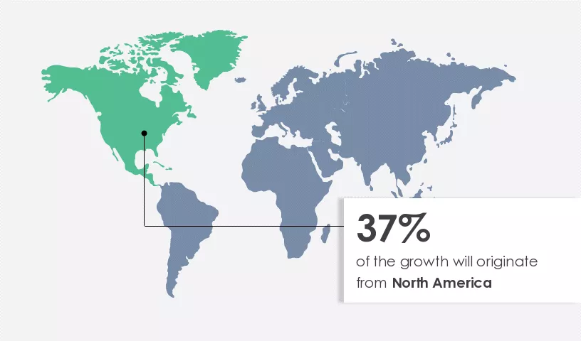
North America is estimated to contribute 37% to the growth of the global market during the forecast period, as indicated by market growth analysis. Technavio’s analysts have elaborately explained the regional trends and drivers that shape the market during the forecast period in their market research report.
Being a pioneer in the adoption of advanced technologies across industries, North America is an attractive market for GIS solutions, highlighted in market trends and analysis. The US stands out as one of the most attractive markets in the region for GIS solutions, serving as a key revenue contributor due to its status as the industrial capital of the world and its early adoption of advanced technologies. GIS solutions find extensive use in the healthcare and telecommunications sectors in the US. Similarly, Canada also contributes significantly to the market in the region, with the government actively framing several action plans to revamp the healthcare sector and efficiently use available resources, further driving market research and growth.
Furthermore, the industrial sector across the region is developed and technologically mature, as observed in market growth and forecasting. This maturity leads to an abundance of success stories, which in turn accelerates the rate of technology adoption. Additionally, the strong presence and penetration of top companies supplement the overall market growth in the region, underlining the importance of market research and growth. Therefore, all the abovementioned factors will boost the regional market during the forecast period.
The Geographic Information System Market witnesses growth through expanded applications in disaster management, leveraging Spatial Data Analysis. Utilized in forest fire and flood management, GIS technology provides crucial data for expert inspection. A significant trend is the demand for technology miniaturization, enhancing Geospatial Technology capabilities.
However, a key challenge lies in data privacy and security concerns, particularly with increased connectivity and data sharing. Addressing these concerns is crucial for maintaining the integrity of GIS Applications in various sectors like Environmental Management and Urban Planning.
The rising applications of GIS solutions in disaster management are notably driving the market. The use of GIS solutions across various systems, such as forest fire management, flood management, climate change analyses, and carbon management, has made GIS technology an effective tool in disaster management. The technology provides data on the geography, and any changes or deviations in the typical data will lead to an inspection by experts. Hence, the government sector and the natural resources sector are heavily dependent on this technology for disaster management.
For instance, the GIS applications of forest fire management, including fire risk assessment, prescribed burn planning, forest fire simulation, and post-fire assessment and monitoring, help in simulating a forest fire. The application takes into consideration the fire-starting point, topography, and vegetation coverage using remote sensing and the wind flow velocity, which directs accordingly. Therefore, the use of modern technologies for disaster management and the increasing use of GIS solutions in such technologies are expected to drive the market during the forecast period.
Rising demand for the miniaturization of technologies is a major trend. The integration of GIS software is increasing the need to create smaller, inexpensive devices with wireless connectivity, thereby expanding the penetration of the IoT. The development of miniaturized, low-cost sensors is leading to an increase in data collection and the ability to adjust the sensor to specific data collection needs.
Furthermore, the rapid miniaturization of GIS technology has made it feasible to explore new methods for sensor distribution. For instance, Smallsat and UAS can be rapidly deployed with a tailored flight path. These miniaturized geospatial sensor platforms enhance the capabilities of both government and business organizations, especially in collecting volumes of remotely sensed critical data, including that related to disaster response, environmental monitoring, and public safety. Thus, the rising demand for the miniaturization of technologies is one of the growing trends that is expected to drive growth during the forecast period.
Data privacy and security concerns are major challenges. Data privacy and security concerns are the key challenges in any organization as devices are interconnected to the internet and dependent on the use of private and public networks. As critical data is transferred through organizations' system networks, a highly secured environment needs to be established. Moreover, an organization's system network includes multiple devices, which at times may cause interoperability issues.
Increased connectivity and data sharing have led to more cybersecurity issues and data breaches. Earlier, cybersecurity was concentrated on a limited number of connected devices. However, due to the IoT revolution, there will be a large-scale combination of both physical and virtual worlds. Potential economic loss from cyberattacks in industries is significant compared with the privacy breaches of personal data. Therefore, cyberattacks can hamper the sensor and device data in an industrial setup. Thus, the possibility of cyber intrusion will adversely affect during the forecast period.
Key Customer Landscape
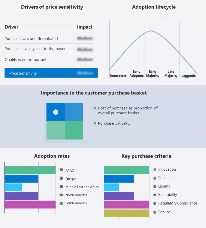
The report includes the adoption lifecycle, covering the innovator’s stage to the laggard’s stage. It focuses on adoption rates in different regions based on penetration. Furthermore, the report also includes key purchase criteria and drivers of price sensitivity to help companies evaluate and develop their growth strategies.
Global Customer Landscape
Companies are implementing various strategies, such as strategic alliances, partnerships, mergers and acquisitions, geographical expansion, and product/service launches, to enhance their presence in the market.
AmigoCloud Inc. - The company offers services like public infrastructure mapping, transportation trip urban planning, natural resource management, and many more. The key offerings of the company include GIS services.
The report also includes detailed analyses of the competitive landscape of the market and information about 15 key companies, including:
Qualitative and quantitative analysis of companies has been conducted to help clients understand the wider business environment as well as the strengths and weaknesses of key players. Data is qualitatively analyzed to categorize companies as pure play, category-focused, industry-focused, and diversified; it is quantitatively analyzed to categorize companies as dominant, leading, strong, tentative, and weak.
The Geographic Information System Market is witnessing unprecedented growth with the rise of Geospatial Technology. From Mapping Software to Location Intelligence, the sector is redefining Cartography and Data Visualization.
Industry Applications span diverse fields like Environmental Management, Transportation Planning, and Agriculture, addressing Regulatory Compliance and mitigating Environmental Impact. Consumer Preferences for precise information drive demand for advanced Technology Advancements in Data Integration and Data Management.
Maps have evolved into powerful tools for Visual Representation across Geographic Locations, supporting Startups and established Businesses alike. Hardware such as GNSS and GPS Antennas, along with technologies like LiDAR and Satellite Imagery, fuel the industry's growth.
Geocoding Services and Spatial Analysis Tools enable tasks like Digital Elevation Models and Land Use Mapping, while Location-Based Services and Real-Time Mapping facilitate Geofencing and Network Analysis.
The market caters to various sectors, from Asset Management to Climate Change Modeling and Disaster Risk Assessment. Innovations like Precision Agriculture and Wildlife Tracking underscore the transformative potential of GIS technologies in shaping our world.
The report forecasts growth by revenue at global, regional & country levels and provides an analysis of the latest trends and growth opportunities from 2017 to 2027.
|
GIS Market Scope |
|
|
Report Coverage |
Details |
|
Page number |
171 |
|
Base year |
2022 |
|
Historic period |
2017-2021 |
|
Forecast period |
2023-2027 |
|
Growth momentum & CAGR |
Accelerate at a CAGR of 16.42% |
|
Market growth 2023-2027 |
USD 13.43 billion |
|
Market structure |
Fragmented |
|
YoY growth 2022-2023(%) |
15.66 |
|
Regional analysis |
North America, Europe, APAC, South America, and Middle East and Africa |
|
Performing market contribution |
North America at 37% |
|
Key countries |
US, Canada, China, Germany, and UK |
|
Competitive landscape |
Leading companies, Market Positioning of companies, Competitive Strategies, and Industry Risks |
|
Key companies profiled |
Alphabet Inc., AmigoCloud Inc., Autodesk Inc., Bentley Systems Inc., Caliper Corp., Computer Aided Development Corp. Ltd., Esri, General Electric Co., Hexagon AB, Hi Target, Mapbox Inc., Maxar Technologies Inc., Pitney Bowes Inc., Rolta India Ltd., Scanpoint Geomatics Ltd., Takor Group Ltd., TomTom International BV, Topcon Corp., Trimble Inc., and UrtheCast Corp. |
|
Market dynamics |
Parent market analysis, Market growth inducers and obstacles, Fast-growing and slow-growing segment analysis, COVID-19 impact and recovery analysis and future consumer dynamics, and Market condition analysis for the forecast period. |
|
Customization purview |
If our report has not included the data that you are looking for, you can reach out to our analysts and get segments customized. |
We can help! Our analysts can customize this report to meet your requirements. Get in touch
1 Executive Summary
2 Market Landscape
3 Market Sizing
4 Historic Market Size
5 Five Forces Analysis
6 Market Segmentation by Product
7 Market Segmentation by Deployment
8 Customer Landscape
9 Geographic Landscape
10 Drivers, Challenges, and Trends
11 Vendor Landscape
12 Vendor Analysis
13 Appendix
Get lifetime access to our
Technavio Insights


