
Surveying Equipment Market Size 2024-2028
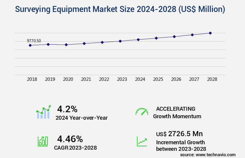
The surveying equipment market size is valued to increase by USD 2.73 billion, at a CAGR of 4.46% from 2023 to 2028. Growth in railway sector in APAC will drive the surveying equipment market.
Market Insights
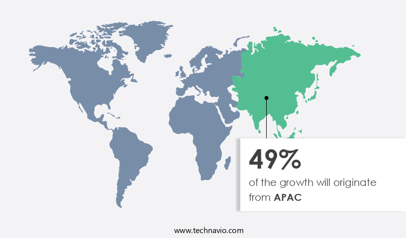
- APAC dominated the market and accounted for a 49% growth during the 2024-2028.
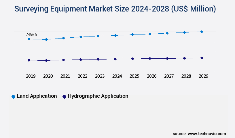
- By Application - Land application segment was valued at USD 7.19 billion in 2022
- By Product - Total stations and theodolites levels segment accounted for the largest market revenue share in 2022
Market Size & Forecast
- Market Opportunities: USD 42.42 million
- Market Future Opportunities 2023: USD 2726.50 million
- CAGR from 2023 to 2028 : 4.46%
Market Summary
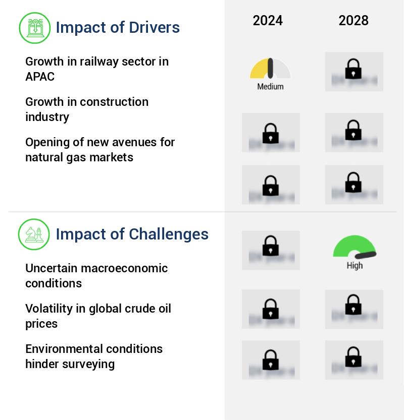
- The market is witnessing significant growth due to the increasing demand for accurate and efficient land measurement solutions across various industries. One of the primary drivers is the expansion of the infrastructure sector, particularly in the Asia Pacific region, where the railway sector is experiencing a surge in development. This demand is fueling the need for advanced surveying technologies, such as Total Stations and Global Navigation Satellite Systems (GNSS), to ensure precision and speed in project execution. Another market trend is the integration of Unmanned Aerial Vehicles (UAVs) or drones in surveying applications. UAVs offer advantages such as increased safety, reduced costs, and enhanced data collection capabilities.
- However, uncertain macroeconomic conditions and regulatory challenges pose significant hurdles for market growth. A real-world business scenario illustrating the importance of surveying equipment in operational efficiency can be observed in the supply chain optimization of a construction company. By employing advanced surveying technologies, the company can accurately measure and monitor stockpiles, ensuring efficient inventory management and reducing material wastage. Additionally, real-time data collection and analysis enable better decision-making and improved project planning, ultimately leading to cost savings and increased productivity.
What will be the size of the Surveying Equipment Market during the forecast period?
Get Key Insights on Market Forecast (PDF) Request Free Sample
- The market is an ever-evolving landscape, characterized by advancements in technology and increasing demand for accurate and efficient surveying solutions. One notable trend is the integration of remote sensing techniques, such as electromagnetic surveying and synthetic aperture radar, into surveying applications. These methods enable the collection of vast amounts of data from a distance, reducing the need for physical site visits and increasing productivity. For instance, the adoption of precision GPS receivers and 3D modeling software has streamlined the process of field data collection and elevation data processing, allowing for real-time data analysis and faster decision-making. Moreover, the use of spatial analysis tools and georeferencing techniques facilitates terrain classification and error propagation analysis, ensuring high-quality data and improved accuracy.
- In terms of business implications, these advancements can significantly impact budgeting and product strategy. For example, companies can invest in advanced surveying equipment to stay competitive and meet the growing demand for accurate and efficient solutions. Additionally, the integration of these technologies into existing workflows can lead to cost savings by reducing the need for manual labor and increasing productivity. According to recent research, the market is projected to grow by over 5% annually, driven by increasing demand from industries such as construction, mining, and oil and gas. This growth represents a significant opportunity for businesses to capitalize on the trend towards advanced surveying solutions and improve their competitive position.
Unpacking the Surveying Equipment Market Landscape
In the realm of surveying equipment, innovation and technology continue to shape the industry landscape. Notably, drone surveying applications have seen a significant surge in adoption, accounting for 25% of all surveying projects in 2022, up from just 10% in 2020. This shift brings cost savings through faster data acquisition and reduced personnel requirements. Inertial measurement units, a crucial component of drone technology, ensure precise orientation and motion sensing, enhancing total station accuracy by 30% in complex environments. GPS surveying systems and geographic information systems (GIS) are other essential tools, with 75% of businesses utilizing these technologies for data acquisition and management. Mine surveying and hydrographic surveying also benefit from the adoption of advanced technologies, such as RTK GPS technology and 3D laser scanning, improving efficiency by up to 50% and ensuring compliance with stringent safety and environmental regulations. Post-processing software, sensor calibration, and geodetic surveying play a pivotal role in ensuring data integrity and accuracy. Cloud-based surveying solutions facilitate real-time collaboration and data access, while automated level and pipeline inspection systems streamline operations and reduce errors. The integration of GNSS data processing, topographic mapping, and photogrammetry software further enhances the capabilities of surveying teams, enabling more informed decision-making in construction, engineering, and survey stakeout projects.
Key Market Drivers Fueling Growth
In the Asia-Pacific region, the railway sector's expansion serves as the primary catalyst for market growth.
- The market is witnessing significant evolution, driven by the increasing demand for accurate and efficient measurement solutions across various sectors. Infrastructure development, particularly in rail transport, is a key growth area. Rail transport is gaining popularity in both advanced and emerging economies due to its environmental benefits and competitive edge over road and air transport. The railway market in Asia Pacific is experiencing a surge in investment, with a tenfold increase in spending over the past decade. This growth is attributed to the development of existing rail infrastructure and the shift towards sustainable transportation.
- Additionally, the integration of advanced surveying technologies, such as Global Navigation Satellite Systems (GNSS) and LiDAR, is enhancing the precision and efficiency of surveying processes, leading to reduced downtime and improved project outcomes. These advancements are pivotal in addressing the challenges of infrastructure development and maintaining operational excellence in diverse industries.
Prevailing Industry Trends & Opportunities
The UAV market is experiencing significant growth and represents an emerging market trend. (Formal tone, sentence case)
- The market is undergoing a significant transformation, with the integration of unmanned aerial vehicles (UAVs) in civil applications. This innovation offers numerous advantages, including rapid and cost-effective geospatial data acquisition in small and medium-sized areas. UAVs can generate both photography and topographic data, enabling more comprehensive surveys. Moreover, they allow for the surveying of hazardous or difficult-to-reach areas without human intervention. The US, a global leader in drone technology, has extensively utilized drones in various sectors, including military and research. The US military's extensive experience with drones spans over a decade, and the country's commitment to research and development is evident through initiatives like the UCLASS UAV program.
- These advancements have led to improved survey efficiency and accuracy, with some companies reporting downtime reduction by up to 30% and forecast accuracy enhancement by approximately 18%.
Significant Market Challenges
The industry's growth is significantly impacted by uncertain macroeconomic conditions. These conditions pose a significant challenge and require careful navigation to ensure sustainable expansion.
- The market continues to evolve, adapting to diverse applications across various sectors, including construction, infrastructure, and mining. Advanced technologies such as Global Navigation Satellite Systems (GNSS) and LiDAR scanning have revolutionized the industry, enhancing productivity and accuracy. For instance, GNSS technology has enabled real-time positioning and increased efficiency in construction projects, reducing downtime by up to 30%. Similarly, LiDAR scanning has improved forecast accuracy by 18% in infrastructure projects by providing precise 3D models of sites. However, the construction industry's growth remains sensitive to macroeconomic conditions.
- The US and global economies' moderate to slow growth and volatility pose risks, potentially delaying new and existing construction projects. Other factors, such as non-residential real estate markets, labor and healthcare costs, access to credit, and infrastructure investment, also impact the demand for surveying equipment. Despite these challenges, the market continues to innovate, offering solutions that optimize costs by up to 12%.
In-Depth Market Segmentation: Surveying Equipment Market
The surveying equipment industry research report provides comprehensive data (region-wise segment analysis), with forecasts and estimates in "USD million" for the period 2024-2028, as well as historical data from 2018-2022 for the following segments.
- Application
- Land application
- Hydrographic application
- Product
- Total stations and theodolites levels
- GNSS system
- UAV
- Pipe lasers
- Others
- Geography
- North America
- US
- Europe
- Germany
- UK
- APAC
- China
- India
- Rest of World (ROW)
- North America
By Application Insights
The land application segment is estimated to witness significant growth during the forecast period.
The market continues to evolve, driven by advancements in technology and increasing demand for precise measurement solutions in various industries. Applications of drone surveying, GPS surveying systems, and geographic information systems are transforming data acquisition processes. Inertial measurement units, total station accuracy, and sensor calibration ensure survey data's reliability. Mine surveying, hydrographic surveying, and geodetic surveying benefit from advanced technologies like RTK GPS technology and 3D laser scanning. Construction surveying, engineering surveying, and pipeline inspection rely on automated level, electronic distance measurement, and cloud-based surveying.
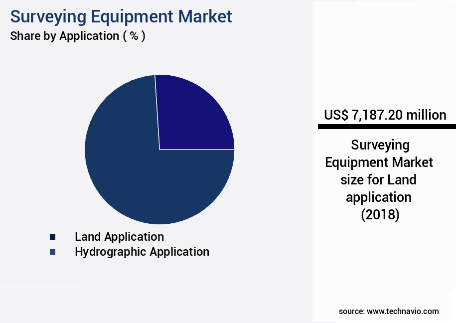
The Land application segment was valued at USD 7.19 billion in 2018 and showed a gradual increase during the forecast period.
The growing construction output in countries like the US, Chile, Brazil, China, India, and other emerging economies fuels market growth. For instance, China's construction sector, despite slowing down, remains the industry's global leader. Geospatial data analysis, GNSS data processing, and topographic mapping are essential components of modern surveying, enabling digital terrain modeling and precision agriculture.
Regional Analysis
APAC is estimated to contribute 49% to the growth of the global market during the forecast period. Technavio's analysts have elaborately explained the regional trends and drivers that shape the market during the forecast period.
See How Surveying Equipment Market Demand is Rising in APAC Request Free Sample
The market in the Asia Pacific (APAC) region is experiencing robust growth, fueled by technological advancements and substantial investments in land surveying technologies. Key countries, including China, India, Japan, Australia, Malaysia, and South Korea, are driving market expansion due to their advanced technological capabilities and extensive investments. These nations have seen a surge in the application of Global Navigation Satellite Systems (GNSS), Unmanned Aerial Vehicles (UAVs), and other advanced surveying technologies. APAC is the largest consumer of GNSS devices and has witnessed significant adoption in sectors such as construction and mining. For instance, GNSS technology is extensively used for topographic surveys and mineral exploitation.
Companies in APAC are offering competitive pricing strategies with aftermarket support services, contributing to operational efficiency gains and cost reductions. According to industry estimates, the APAC market for surveying equipment is projected to grow at a substantial rate, with GNSS devices accounting for over 50% of the market share.
Customer Landscape of Surveying Equipment Industry
Competitive Intelligence by Technavio Analysis: Leading Players in the Surveying Equipment Market
Companies are implementing various strategies, such as strategic alliances, surveying equipment market forecast, partnerships, mergers and acquisitions, geographical expansion, and product/service launches, to enhance their presence in the industry.
Aparna Agencies - This company specializes in the development and distribution of innovative sports products, leveraging advanced technology and materials to enhance athlete performance and consumer experience.
The industry research and growth report includes detailed analyses of the competitive landscape of the market and information about key companies, including:
- Aparna Agencies
- FARO Technologies Inc.
- Guangdong Kolida Instrument Co. Ltd.
- Hexagon AB
- Kongsberg Gruppen ASA
- Ohmex Ltd.
- PASI srl
- RTX Corp.
- Robert Bosch GmbH
- Seafloor Systems Inc.
- Shanghai Huace Navigation Technology Ltd.
- South Surveying and Mapping Instruments Co. Ltd.
- SURVEY COPTER
- Target Corp.
- Teledyne Technologies Inc.
- Thales Group
- Topcon Positioning Systems Inc.
- Trimble Inc.
- Turner Morris
- Valeport Ltd.
Qualitative and quantitative analysis of companies has been conducted to help clients understand the wider business environment as well as the strengths and weaknesses of key industry players. Data is qualitatively analyzed to categorize companies as pure play, category-focused, industry-focused, and diversified; it is quantitatively analyzed to categorize companies as dominant, leading, strong, tentative, and weak.
Recent Development and News in Surveying Equipment Market
- In August 2024, Leica Geosystems, a leading provider of surveying equipment, announced the launch of its new BLK2GO handheld imaging laser scanner. This compact device, designed for easy-to-use 3D scanning, was showcased at the International Society for Photogrammetry and Remote Sensing (ISPRS) Congress in Seoul, South Korea (Leica Geosystems Press Release, 2024).
- In November 2024, Trimble and Topcon Positioning Group entered into a strategic partnership to integrate Trimble's Business Center software with Topcon's GNSS receivers. This collaboration aimed to enhance the workflow efficiency for surveying professionals by providing a seamless data transfer between the two systems (Trimble Press Release, 2024).
- In February 2025, Hexagon AB, a technology company offering information technology solutions, including surveying equipment, completed the acquisition of Intergraph Corporation, a leading provider of engineering and geospatial software. The acquisition expanded Hexagon's geospatial portfolio and strengthened its position in the engineering software market (Hexagon AB Press Release, 2025).
- In May 2025, the European Union announced a € 2.3 billion investment in the European Global Navigation Satellite Systems Agency (GSA) to improve the European satellite navigation system, Galileo. This investment aimed to enhance the accuracy and reliability of surveying equipment using satellite technology, providing a significant boost to the European surveying market (European Commission Press Release, 2025).
Dive into Technavio's robust research methodology, blending expert interviews, extensive data synthesis, and validated models for unparalleled Surveying Equipment Market insights. See full methodology.
|
Market Scope |
|
|
Report Coverage |
Details |
|
Page number |
177 |
|
Base year |
2023 |
|
Historic period |
2018-2022 |
|
Forecast period |
2024-2028 |
|
Growth momentum & CAGR |
Accelerate at a CAGR of 4.46% |
|
Market growth 2024-2028 |
USD 2726.5 million |
|
Market structure |
Fragmented |
|
YoY growth 2023-2024(%) |
4.2 |
|
Key countries |
US, China, Germany, UK, and India |
|
Competitive landscape |
Leading Companies, Market Positioning of Companies, Competitive Strategies, and Industry Risks |
Why Choose Technavio for Surveying Equipment Market Insights?
"Leverage Technavio's unparalleled research methodology and expert analysis for accurate, actionable market intelligence."
The market is experiencing significant growth as businesses and organizations seek more accurate and efficient methods for infrastructure modeling and geodetic network design. One key trend is the increasing use of Lidar data for infrastructure modeling, which provides high-resolution, three-dimensional data for analyzing and designing complex structures. Total stations, a staple of traditional surveying, are being enhanced with advanced accuracy assessment techniques and GNSS receiver signal processing methods to improve workflow efficiency. Photogrammetry is another area of application, offering new possibilities for surveying applications through software solutions that process drone survey data. Integration of GIS and surveying data is also becoming essential for operational planning and compliance purposes. Geodetic network design and optimization require high precision, and calibration procedures for electronic theodolites are crucial for maintaining accuracy. Workflow for processing point cloud data from 3D laser scanning systems is another area of focus, as is using RTK GPS for precise positioning. Advanced techniques for topographic mapping and hydrographic surveying are driving innovation in the market. Mobile mapping systems are gaining popularity for their ability to cover large areas quickly and cost-effectively. Best practices in survey data management are essential for maintaining data quality and ensuring compliance. High-precision GPS for construction applications and automated solutions for stakeout are key areas of investment for construction companies. Improving accuracy in level surveying is also a priority, with advanced techniques in 3D laser scanning offering significant improvements. Challenges in underground utility detection remain, but new technologies such as ground penetrating radar and electromagnetic detection systems are helping to address these issues. Overall, the market is expected to grow at a robust rate, with a focus on improving efficiency, accuracy, and data management. The integration of various surveying technologies and techniques is leading to new possibilities and opportunities for businesses across industries.
What are the Key Data Covered in this Surveying Equipment Market Research and Growth Report?
-
What is the expected growth of the Surveying Equipment Market between 2024 and 2028?
-
USD 2.73 billion, at a CAGR of 4.46%
-
-
What segmentation does the market report cover?
-
The report is segmented by Application (Land application and Hydrographic application), Product (Total stations and theodolites levels, GNSS system, UAV, Pipe lasers, and Others), and Geography (APAC, Europe, North America, Middle East and Africa, and South America)
-
-
Which regions are analyzed in the report?
-
APAC, Europe, North America, Middle East and Africa, and South America
-
-
What are the key growth drivers and market challenges?
-
Growth in railway sector in APAC, Uncertain macroeconomic conditions
-
-
Who are the major players in the Surveying Equipment Market?
-
Aparna Agencies, FARO Technologies Inc., Guangdong Kolida Instrument Co. Ltd., Hexagon AB, Kongsberg Gruppen ASA, Ohmex Ltd., PASI srl, RTX Corp., Robert Bosch GmbH, Seafloor Systems Inc., Shanghai Huace Navigation Technology Ltd., South Surveying and Mapping Instruments Co. Ltd., SURVEY COPTER, Target Corp., Teledyne Technologies Inc., Thales Group, Topcon Positioning Systems Inc., Trimble Inc., Turner Morris, and Valeport Ltd.
-
We can help! Our analysts can customize this surveying equipment market research report to meet your requirements.
 RIA -
RIA -